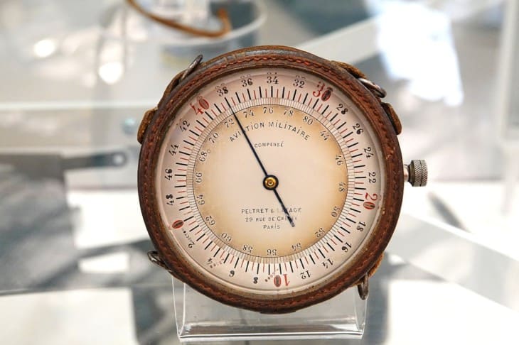
At first glance, the altimeter in an airplane seems like a relatively simple instrument. And it does work in a simple way, but not like most people would think it would. Pilots need to understand their instruments inside and out to get the right information out of them, and that’s especially true with something as important as the plane’s altimeter.
How Does an Altimeter Work?
Altimeters measure changes in atmospheric pressure as the plane climbs or descends. It has no reference to the ground or even sea level. When correctly set, the altimeter reads height above mean sea level, known as MSL.
The altimeters found in aircraft are barometric sensitive altimeters. They are simple devices that measure changes in air pressure. They cannot reference the ground in any way, so it is impossible for them to accurately indicate height above ground level (AGL) without the pilot making some careful calculations.
The altimeter’s case is connected to the aircraft’s static instrument system, so it is exposed to an accurate reading of outside air pressure. A stack of evacuated sealed aneroid chambers inside the altimeter tries to expand while air pressure tries to compress them. As a result, they change their shape as atmospheric pressure changes, and the needles are calibrated to show that change in feet or meters.

A barometric altimeter is calibrated using the standard lapse rate for pressure, which decreases 1.00” Hg (inch of mercury) for every 1,000 feet altitude increases. For example, if an airplane departed a sea-level field on a standard day (29.92 inches of mercury or 1013.2 millibars) and climbed until the altimeter senses the pressure of 28.92″ Hg, then the altimeter should indicate 1,000 feet.
It is up to the pilot to set the current altimeter setting into the Kollsman window on their altimeter for the indicated altitude to be accurate. Failure to set the correct altimeter setting will result in significant errors.
For this reason, altimeter settings are frequently provided in aviation. Whenever a pilot contacts a new air traffic controller or gets the weather for any airport, the altimeter setting is one of the essential pieces of information received.
Altimeter settings are always corrected to sea level. With all airports and all pilots using sea level as a reference, all altimeters should be indicating the height above sea level or MSL. When on the ground at the airport, an altimeter should be equal to the field’s elevation above sea level.
Reading Your Altimeter
Altimeters usually have three hands, much like a clock. The “small hand” points to hundreds of feet, and the “big hand” points to thousands. There is also a smaller outer pointer that points to tens of thousands of feet.
Like an old-school analog clock, it’s essential to realize that as the hands or pointers move, they will get closer to the next number. For example, it’s easy to misread an altimeter reading 8,900 feet as 9,900 feet.

Indicated Altitude and Altimeter Errors
The number read on the instrument face is called the indicated altitude. This may or may not represent height above MSL. It depends on whether or not the pilot has set the correct altimeter setting.
As noted, the temperature can change the distance between pressure levels. The altimeter has no way to compensate for temperature, so pilots must be aware that indicated altitude may not equal true altitude, especially when it is very hot or very cold.
Since warm temperatures expand the pressure levels, indicated altitude would be lower than true altitude on a very hot day. While not ideal, this does not pose a danger since this would give a plane more distance between the land and obstacles.
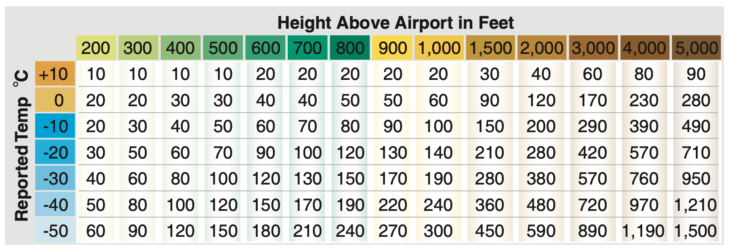
On very cold days, however, the pressure levels are compressed together, and the pilot will need to take action to prevent problems. A calibration chart provides the appropriate amount to add to the planes indicated altitude to ensure it remains as close as possible to true altitude.
How altimeters work, and the errors associated with them, is covered in the FAA’s Instrument Flying Handbook, Chapter 5: Flight Instruments.
Radar Altimeters
Large aircraft are often fitted with radar or radio altimeters that measure height AGL when near the ground. These are often connected to callout systems and coupled to autoland and other automation. Standard callouts in the cockpit of radio altimeter equipped aircraft include 2,500 feet, 1,000 feet, 500, 100, 50, 40, 30, 20, and 10. Radio altimeters are a great help when over the runway at an airport and help cue the pilot for their landing flare.

GPWS, or ground proximity warning systems, uses radio altimeters to alert the pilot if the flight is operating too close to terrain. If the plane is not set up for landing (low power, flaps down) and the system senses terrain, a callout warning is sounded, “Terrain pull up, pull up!”
Related Posts
- Mayday Call: Diving Into This Vital Distress Signal
- Headwinds vs Tailwinds: What's the Difference for Pilots?
- What is a Bush Pilot and how to become one
About the Author